Q&A
SEGRO Logistics Park Radlett Q&A
General development
This is a complex and wide-ranging construction project, and it is not feasible to provide a detailed commentary on every aspect of the works. However, once the construction schedule is finalised and the main works start, we will provide more information than is currently available, as well as drawings and plans.
We have incorporated new features for example the “Indicative Views” tab which enables people to drill down into the detail more easily. We continue to provide high-level information and update the key dates and Q&A section, as well as notifying residents directly in relation to any specific programmes taking place close to their properties. Users can also set up their own alerts and in addition we will notify parties who have requested updates.
Prior to the main construction works we commenced works to prepare the site. This included survey works, tree and scrub removals, establishment of the main compound and localised earthworks in Areas 1 and 2. The main site access point is now operational from the A414.
The first major construction milestone at SEGRO Logistics Park Radlett was delivered successfully during the Christmas 2024 period with the installation of a vital underbridge beneath the Midland Main Line.
We expect the main earthworks, infrastructure, highways and utility work to begin in the second half of 2025 and be completed by December 2027. It is anticipated that the buildings will be constructed between 2027 and 2030, but the specific timings are dependent on when we agree the leases with occupiers.
The outline planning permission for SEGRO Logistics Park Radlett is for 7 warehouses of differing sizes in addition to the rail freight terminal. The final size and configuration of the warehouses could vary depending on detailed planning permission and the leases agreed with customers.
According to Heathrow Airport’s website, Terminal 5 measures 353,020 square metres and is 40 metres in height. Terminal 5 is larger than the total planned logistics space at Radlett and Terminal 5 is twice the height of any permitted warehouse. SEGRO Logistics Park Radlett includes 600 acres of managed green space which is a significant portion of its total area against Heathrow’s Terminal 5 which does not have comparable green space allocation.
The planning permission allows for 24/7 working, which is normal for a logistics park of this nature. There will be peaks and troughs of activity within any 24-hour period. Measures, such as a large earth bund around the edge of the development and new road infrastructure will be put in place to mitigate the impact of these operations for residents.
Whilst this development will inevitably lead to a loss of green space, it will provide investment to enhance and improve the management and accessibility of the Country Park which, unlike the development site, is open to the public.
SEGRO is implementing a Countryside Management Plan to enhance biodiversity and improve natural habitats for the benefit of locally important wildlife sites including the Ver Valley Meadows. There will be a range of new footpaths, bridleways, nature trails and multiuse routes along with improvements to existing rights of way, totalling c.17km.
SEGRO has set up a Country Park Liaison Steering Group. This wide-ranging group of stakeholders will help oversee progress.
We are actively engaging with local users and associations on matters such as flooding to achieve access to all areas all year round where possible.
No SEGRO cannot develop these areas. Condition 3 of the outline permission states that the development must be in accordance with the agreed key parameters plan. This plan clearly shows the country park areas as being publicly accessible open space, and limits development to the main site.
Noise and dust monitoring requirements have been agreed with the local authorities and will be implemented throughout the project. Standard measures in line with construction industry best practice will be put in place. Through our contractors, we will take steps to address any issues should they occur.
We anticipate that we will start building the first of the warehouses in 2027. We are likely to adopt a pre-let approach, which means that we will only start building a warehouse once we have a customer to occupy it. This approach means that we cannot provide specific timescales for occupation at this time. It is also worth noting that no warehouses can be occupied until the Strategic Rail Freight Interchange is capable of operation, which will not be until late 2026.
Much of the hoarding has been erected so that it can remain in place until the works are completed for safety and security reasons. This is normal for major construction projects of this type. Some sections may require removal earlier to enable construction activities.
UK planning law does not require compensation to be paid to residents for local developments that have been granted planning permission. Instead, the planning system is designed to weigh up the public benefits of a development against its potential impacts on the local area and focuses on mitigation measures, which are often included as conditions in the planning permission or improvements to community infrastructure through mechanisms like Section 106 agreements.
SEGRO’s planning permission includes a Section 106 contribution, which will be implemented by Herts County Council, and planning conditions requiring the investment of millions of pounds into improvements to local roads.
In UK planning, an NMA stands for Non-Material Amendment. It refers to a change to an existing planning permission that doesn’t significantly alter the approved development.
There is no statutory definition of what constitutes a non-material amendment. Instead, developers like SEGRO have to consider a range of factors, such as the scale and impact of the change, and based on their experience on other projects, make a judgement on whether the local planning authority will consider it a material or non-material change. SEGRO will engage with St Albans District Council both before and during the submission to understand their position, before making an application.
Public liaison
If you have any queries relating to SEGRO Logistics Park Radlett you should contact SEGRO directly via the enquiry form. We have a dedicated public liaison officer who will endeavour to respond to your query in a timely manner.
Alternatively, you can contact your local elected Councillors.
Contact details for County Councillors can be found at https://www.hertfordshire.gov.uk
Contact details for District and Parish Councillors can be found at
We are adopting a community first approach, which means that we want our neighbours to be aware of what we are doing before we start doing it. We will be communicating directly with immediate neighbours about specific works that are close to their property or may be disruptive to their daily lives.
We are already running a Community Liaison Group which consists of local councillors and resident associations. The groups meets approximately every 2 months for scheme updates and feedback.
We have created a Country Park Liaison Steering Group which meets twice a year to oversee and discuss Country Park matters.
This website is a key source of information for local people, and we are committed to keeping it up to date throughout the delivery of the project.
In addition to the website and our dedicated public liaison officer who will use a variety methods to share information with the community. .
The creation of a development such as SEGRO Logistics Park Radlett is a significant and complex undertaking, and while we will take every practical step to minimise disruption we understand that our neighbours may still have some concerns.
If you have concerns or other thoughts, please contact us using our website enquiry form.
Community Investment
SEGRO has made a commitment to create and implement Community Investment Plans for all our key markets and we are currently developing a Community Investment Plan (CIP) for SEGRO Logistics Park Radlett.
We believe that building strong and positive relationships with and investing in our local communities is important and we have a strong track record of doing so that spans our 105-year history.
At SEGRO’s developments many residents from the immediate local area are employed by our customers, so establishing networks with community stakeholders across the local area including grass-roots community organisations is essential.
We work with a range of diverse community partners who have knowledge and insight of the most pressing local challenges our communities face as well as the expertise to ensure we deliver an impactful and outcome-driven programme. The aim is to support those who need our help the most.
Through our CIPs we aim to identify, support, and ultimately fund local programmes and initiatives that fall into these key areas:
- Employment and Skills – helping local people to develop the right skills to get a job;
- Education – inspiring the next generation of young people with the world of work and possibly the property and logistics sectors;
- Economy – helping the local economy to thrive;
- Environment - delivering environmentally led community projects that enhance biodiversity and improve health and wellbeing.
If you would like to find out more about the CIP scheme for Radlett please use the contacts link.
Alternatively, you can contact your local elected Councillors.
Contact details for County Councillors can be found at
https://www.hertfordshire.gov.uk/home.aspx
Contact details for District and Parish Councillors can be found at
Rail
Network Rail owns and develops the UK’s rail infrastructure and is required to balance the interests of both passenger and freight operations. We have liaised closely with Network Rail to plan for the creation of the Strategic Rail Freight Interchange and will continue to work with them in relation to the works to link the terminal into the rail network.
Network Rail will manage and communicate these works in the same way as any other upgrade to the rail network with an aim of keeping disruption to a minimum.
Regarding the operation of freight trains, paths will be made available by Network Rail in agreement with train operating companies and the freight operating companies. It is anticipated that these paths will be outside peak times so will not disrupt key morning and evening commuter services.
Yes. None of the units can be occupied until the terminal is capable of operation.
Trains will enter from the south and also depart from the terminal in a southerly direction. London is the hub from where the network branches out to serve all of the key routes around the country, and many of the key container ports (London Gateway, Southampton and Felixstowe) would also be accessed to the south.
No, the terminal is for freight trains only and will not have any of the infrastructure required for passenger trains.
The nearest stations are Park Street and How Wood along with the two St Albans stations. The travel plan envisages connectivity to the stations in St Albans by shuttle bus and the provision of pool bikes for example at Park Street. There will be no passenger train facilities at SEGRO Logistics Park Radlett.
Throughout the planning process we have worked closely with Network Rail to ensure the Strategic Rail Freight Interchange can be accommodated within both the physical constraints of the network and the likely passenger train timetable constraints. At all stages Network Rail has approved our plans.
Network Rail is required to balance the interests of both passenger and freight services and will work with passenger and freight train operators to agree train paths to service the Strategic Rail Freight Interchange at Radlett. There is no reason to believe that it cannot be integrated and become a welcome addition to the rail freight network serving London, the South East and the country as a whole.
The Midland Mainline is part of the Strategic Freight Network and is used to carry passengers and freight.
Like the majority of the rail network it is not gauge cleared to W10 / 12 standards. This does not mean that freight trains can’t use it, it just means that freight operators need to use combinations of low wagons or smaller containers.
Network Rail has plans to upgrade the gauge of Midland Mainline to the south of Radlett and once this work is completed it will make rail freight operations to and from Radlett easier to manage.
As the owner and manager of development SEGRO does not have sight of the occupiers’ day-to-day operations. However, SEGRO will advise future occupiers at SEGRO Logistics Park Radlett of this request and if the customers are willing to collect and supply the data for general publication then SEGRO will facilitate this.
It is worth noting that at our East Midlands Gateway facility, all the occupiers at the development are using the rail freight terminal as part of their logistics operations. Furthermore, occupiers of units of this size are most likely to be large or multi-national corporations, which in most cases will have a pathway to net zero, which rail freight will help them achieve.
Like many other SRFI’s in the UK, it was always intended for the Radlett SRFI to be open access. This means it will be available for use by any company in the region that wishes to use rail to transport containers to other SRFI’s or for the import or export of goods.
Furthermore, SEGRO is making is a significant investment in road to rail modal shift, with this location being the only SRFI serving the London area and enabling more freight to travel around the UK by rail.
Only a small percentage (c. 5%) of freight trains in the UK are hauled by electric locomotives. This is because many of the routes that freight trains need to take have not been electrified and therefore diesel locomotives are the only option. The southern end of the Midland Main Line has been electrified already and as more of the network is upgraded in the future there is potentially more opportunity to increase the number of freight trains powered by electric. We will not be installing electric wires at the terminal at this stage, however, we will not do anything now that precludes them from being installed in the future should circumstances change.
The Section 106 agreement specifies an indexed sum of money to be paid to HCC that is ring fenced for Park Street station improvements. These are improvements to passenger facilities and the street layout in the vicinity of the station. SEGRO has no say in how the money is spent to deliver these improvements.
Roads
SEGRO is investing tens of millions of pounds on the Park Street / Frogmore relief road, the main access roundabout, the Park Street roundabout , the London Colney roundabout and works to J21a and J22 of the M25.
There will be no requirement for Hertfordshire County Council funding. These improvements were identified during the planning process as necessary to mitigate the impact of the scheme and represent a £40m investment into Hertfordshire County Council highways
Highways Improvements include –
• Park Street Roundabout:
Improvements include -an additional A405 entry lane and A414 (east arm) exit lane, additional third circulatory carriageway lane, signalisation on the A414 and A405 arm, and improvements to the A405 pedestrian crossing. The partial signalisation will by design allow easier access from Park Street and Watling Street onto the roundabout.
• A414 new roundabout (reference point being East of Hedges Farm):
A new signalised, all movements roundabout serving the development and Relief Road / Bypass. This allows access and egress to both the eastern and western A414. The HGV’s serving the operational development will access and egress via the A414 new Relief Road roundabout.
• New Relief Road Bypass:
A new Park Street/Frogmore Relief Road between the A414 and A5183. This is for all users with the exception of the HGV’s serving the operational development.
• Measures to divert those HGVs not delivering or originating from Park Street away from using Park Street following the opening of the relief road.
• Measures to ensure that HGVs are restricted from using Watling Street and Harper Lane.
• M25 Jn21a:
Capacity improvements including additional entry lanes (A405 south arm and M25 east bound off-slip), additional circulatory carriageway way lane (east side only), and full signalisation.
• M25 Jn22:
Capacity improvements to the existing Jn22 roundabout on the south side of the M25. Including minor kerb realignment and footway extension (west side of A1081).
Park Street roundabout has been designed with three signalised arms and two priority arms as the most efficient way to control traffic through the junction. Five arm roundabouts with full five arm signalisation tend to perform poorly because of queuing issues on the circulatory carriageway. An “all arms” signalised junction model was produced during the design development and this showed that the additional stop lines required on the circulatory carriageway would lead to an unacceptable level of queuing on the internal circulatory lanes of the junction, which would lead to traffic blocking vehicles trying to exit the roundabout.
We are consulting with the local highway authority, Herts CC to finalise the designs and control measures to deliver the required scheme outcomes. These will be shared and put on our dedicated website in due course.
As the local highway authority, Herts CC is a statutory consultee for all planning applications with transport impact, as well as the authorising authority for any resulting highway works (under Section 278 and Section 38 agreements) required as part of a development. The consented scheme has been built into the Herts highways system and therefore has to be considered as live by all subsequent schemes.
The vast majority of construction traffic enters and leaves the main construction compound via the A414. The compound has ample parking for the employees, contractors and visitors.
Prior to the underbridge being installed at Christmas there had been a requirement to have some low-volume access from the east and southern parts of the existing highway network to provide temporary accesses. However, with the bridge now in place the majority of construction traffic can access the whole site from the main entrance. SEGRO was also conveyed rights of access along Benningfield Drive - a bridleway with rights of access to landowners along the lane. We understand access arrangements are similar to those in place for Springfield Farm, Tarmac and Network Rail which also use the bridleway for vehicle access. SEGRO will keep site access via these routes to a minimum.
Hertfordshire County Council is aware of various access rights SEGRO and our contractors have in relation to the development. These are private rights to use land and are not in breach of the Road Traffic Act.
As part of the planning permission, traffic consultants modelled the anticipated road vehicle movements and designed a number of enhancements to the road network to accommodate the vehicles expected to use SEGRO Logistics Park Radlett.
The highway authorities (Hertfordshire County Council and National Highways) have been consulted at all stages of the planning process and as with any scheme of this size and complexity there will be ongoing discussions with them to secure technical approval and adoption of the detailed design.
Our highways consultant WSP has confirmed that the traffic flow data on the surrounding network (M25, A414, A405 and Watling Street A5183) used to inform the designs for which we have secured planning permission still remains robust.
In an emergency situation, as well as the HGV parking provided for the logistics buildings, there is the ability for HGV to use the private perimeter estate road that serves SEGRO Logistics Park Radlett. This could accommodate circa 200 HGV's.
The routing to and from the facility will be;
1. The north from the M1 junction 8 onto the A414
2. The north from the A1M onto the A414
3. The south from the M25 junction 21 onto the A405 and then the A414
4. The south from the M25 junction 22 onto the A1081 and then the A414
As part of the development proposals, Goods from the site will be restricted from using the roads to the south of the site. The precise details and enforcement methods are still subject to further consultation and agreement with the relevant local authorities.
Sections of the A414 are being widened – namely:
1. Park Street Roundabout including capacity improvements to the existing 5 arm priority roundabout, an additional A405 entry lane and A414 (east arm) exit lane, additional circulatory carriageway lane
2. At the new SRFI A414 access / egress roundabout.
The new Relief Road means that traffic not going to a Park Street business or property has no reason to enter Park Street.
We can only carry out works as per our planning consent. The traffic modelling and adequacy of the measures have been fully tested throughout the planning process and have been accepted by the highway’s authorities. Concerns and issues regarding the areas outside our red line planning boundaries must be taken up with the relevant highway authorities (Hertfordshire County Council and National Highways).
SEGRO Logistics Park Radlett will have its own business conduct standards and will have strict operational arrangements with customers to ensure vehicles enter and leave the site within defined times to ensure goods are transferred efficiently.
The Draft Travel and Freight Monitoring and Management Plan includes maximum targets for peak hour HGV movements of 202 per hour 7am to 9am and 4pm to 6pm. For those vehicles that are coming to the site, there will be HGV parking provided at the logistics buildings and for the Strategic Rail Freight terminal.
It is worth noting that within a 25-mile radius of Radlett there are 17 designated truck stops – the nearest are Flamstead (M1) to the north and South Mimms (M25) to the south.
In an emergency situation, as well as the HGV parking provided for the logistics buildings, there is the ability for HGV to use the private perimeter estate road that serves SEGRO Logistics Park Radlett. This could accommodate circa 200 HGV's.
The proposals for the Park Street roundabout include partial signalisation and measures to improve safety for pedestrians and cyclists. The traffic will also be helped by the relief road which will take pressure off the A5183 through Park Street.
Please go to the download sections for detailed plans of the new roundabout layout.
The traffic modelling and adequacy of the measures have been fully tested throughout the planning process and have been accepted by the highway’s authorities. The traffic modelling also showed that the provision of the new Park Street Relief Road – which forms part of the new infrastructure – would provide the opportunity to remove a significant number of HGV and Light Vehicle traffic from Watling Street (A5183) through Park Street village.
The rail freight terminal and individual buildings will have welfare facilities available for the use of drivers along with significant levels of HGV parking provision.
It is worth noting that within a 25-mile radius of Radlett there are 17 designated truck stops – the nearest are Flamstead (M1) to the north and South Mimms (M25) to the south.
In both cases the speed limits will be determined by Hertfordshire County Council (HCC) in liaison with our highways consultant WSP as part of the technical approval process.
The current speed limit on the A414 is 70mph. WSP is in discussion with HCC about the appropriate speed limit for the relief road where the parties are considering 40mph or 50 mph for the majority of the distance with 30mph close to the southern roundabout.
With the signalisation of the Park Street roundabout and new A414 roundabout increased traffic will flow more seamlessly but at lesser speeds than the current 70mph through these areas.
Please contact your local elected Councillors if you would like to get involved.
There are no plans to carry out new surveys. Our highways consultant, WSP, has reviewed the traffic data on the surrounding network (M25 ,A414 ,A405 and Park Street) and it is consistent with that used to inform our highway designs that have been granted planning permission. Hertfordshire County Council has been consulted throughout the design development process and is aware of the position.
There are no plans to install a new bridge over the M25. The Park Street / Frogmore bypass design provides a link to the A5183 immediately to the north of the existing bridge over the M25. In agreement with Hertfordshire County Council, this solution will be less disruptive for road users than constructing a new bridge over the M25.
Whilst we are looking at all options one solution is to install a CCTV system on the estate with cameras strategically located adjacent to plot entrances. The CCTV system will be capable of being monitored remotely.
This is an approach to security and surveillance that we have used elsewhere in our portfolio which has proven to be effective.
The UK road network is often busy and some disruption as a result of the roadworks cannot be avoided. However, every effort will be made to minimise the impacts on journey times.
Other useful websites for traffic information:
- www.hertfordshire.gov.uK
- https://uk.one.network/communicate/causeway-onenetwork-map
- www.trafficengland.com
- www.roadworks.org
We will publish details of roadworks on this website and send out emails to our registered contacts.
Other useful websites for traffic information:
- www.hertfordshire.gov.uk
- https://uk.one.network/communicate/causeway-onenetwork-map
- www.trafficengland.com
- www.roadworks.org
Yes. There are specific processes to follow for companies such as SEGRO which need to undertake works to the road network or require closures or controls to be put in place. We will liaise with National Highways and Hertfordshire County Council – which manage the roads where we will be undertaking works – to enable them to coordinate them as best as possible with other roadworks in the vicinity of the project.
We will inform stakeholders in a timely fashion of the works, durations and impacts when our sectional programmes are confirmed. Regular updates will be given.
We have given this serious consideration and have explored options with a number of our advisors including a link via Curo Industrial Park. The location of the roads for which we have planning approval were included as part of the original planning applications in relation to the SRFI scheme as far back as March 2009. They have been thoroughly tested through all stages of the planning process. It would not be possible at this stage to change such core elements of the scheme for which we have planning permission without causing unacceptable time delays or having a disproportionately high adverse impact on our costs. Seeking an alternative route now could also compromise the overall planning permission which would not be acceptable to us.
The S106 agreement specifies an indexed sum of money to be paid by SEGRO to HCC for Park Street/ Frogmore Environmental Improvements to include:
• Traffic management measures to be introduced to restrict Heavy Goods Vehicles from using the A5183 in the vicinity of Park Street / Frogmore save those vehicles delivering to addresses in the vicinity of Park Street / Frogmore
• Traffic calming measures
• Footway widening
• Associated townscape and landscape work to improve the environment and residential amenity.
This money is ring fenced for this purpose and SEGRO has no say how these improvements are made or delivered.
Please contact your local elected Councillors if you would like to get involved.
The new layout does provide for some limited new public car parking bays immediately alongside Radlett Road, however, our highway consultant is in discussions with HCC on the precise arrangements for these.
The phone mast and its associated cabinets will be relocated. The exact location is not known at this time but likely to be at the southern end of the units.
A Framework Travel Plan with Herts CC will be agreed as the overarching strategy for the operation of the development as a whole. Individual organisations and occupiers will inevitably choose to tailor plans to their individual needs, and therefore responsibility for the implementation of the plan lies both with the developer and the occupiers. Targets will be agreed and then following occupation under the Framework Travel Plan SEGRO and the occupiers will -
1. Undertake monitoring with analysis of monitoring data and preparation of reports.
2. Submit to Herts CC.
3. Chair Steering Group
The links below take you to the St Albans Planning portal where the Reserved Matters applications are available:
Visual impact
There will be a vegetation-covered earth mound or bund around the site that will separate the warehouses and Strategic Rail Freight Interchange from neighbouring residential properties. The bund is designed to be the optimum size to reduce visual impact while not being overbearing itself. The planning permission includes a detailed specification of the bund. Details are available in planning applications 5/2017/1995, 5/2009/708 and 5/2023/2407 on the St Albans and District Council planning portal.
In terms of visual impact, the SRFI will be screened from most viewpoints by existing and proposed landscape features such as bunds and structured woodland planting.
Drawings are available in Planning Application 5/2017/1995 on the St Albans and District Council planning portal.
If you go “indicative views” tab you will see views of the bund from various locations. In addition we have produced a simplified drawing of the bund heights which is included in the Exhibition Download section of the website.
The bunds themselves are a major element of the construction works. The bunds will be constructed using earth that will be excavated on site to create the level base for the rail terminal and buildings to sit on. The excavation of these materials is in the first phase of work and also means the excess earth doesn’t need to be removed from site via HGVs. We will work with our contractors to plan the most efficient and effective phasing of the bund construction. We will look to seed the bunds and carry out the required planting in the earliest planting season available. Any unsuccessful planting will be replaced as part of the ongoing maintenance.
Air quality, noise and light pollution
St Albans City and District Council have produced a report “Air Quality Action Plan” which outlines the actions that St Albans City and District Council will deliver between 2024 and 2029 in order to reduce concentrations of air pollutants and exposure to air pollution, thereby positively impacting on the health and quality of life of residents and visitors to St Albans. It has been developed in recognition of the legal requirement on the local authority to work towards Air Quality Strategy (AQS) objectives under Part IV of the Environment Act 1995 and relevant regulations made under that part and to meet the requirements of the Local Air Quality Management (LAQM) statutory process.
Please contact SADC Environmental Services for further information on the Air Quality Action Plan.
We were required to address the impact of our development activities on air quality as part of our planning application. These submissions have been examined by the relevant authorities and permission has been granted in acknowledgement that air quality concerns have been addressed.
Air quality will be improved with-
· The 600 acres of woodland and managed countryside, including 200 ac.res of new species-rich mixed woodland planting and 400 acres. of conservation grazing. New areas of woodland (4,288 standard trees, 132,057 whips) hedgerows and managed countryside e.g. conservation grazing, translocation of acid grass land and grass land management.
· The promotion of walking and cycling via the dedicated cycle/footways to be provided along the length of the Park Street Bypass connecting with a signed route into the southeast of St. Albans and London Colney to the east.
· Encouragement of sustainable travel SEGRO through:
Encouraging non-car use and ensure that employees reduce their reliance on the private car for journeys to work.
Ensuring that 5% of parking spaces are allocated as dedicated car-sharing spaces.
Providing shuttle buses between the site, St Albans Stations and Park Street Station; along with works buses.
· Allocate at least 20% of all car parking spaces for EV charging.
As part of the reserved matters planning submission an external lighting strategy (application ref 5/2017/0871) has been produced with careful consideration of the site layout and landscaping to minimise the lighting impact from the development. The current scheme has been modelled to assess the noise impacts (application ref. 5/2016/2963). The impacts were first identified and addressed at the outline stage with mitigation measures put in place including the earth bunds.
Noise from the Park Street relief road and southern access roundabout has been assessed (in the latter case see Southern Access Roundabout and Relief Road Alignment note submitted with application ref .5/2017/1938) and the overall detailed design has provided for acoustic fencing to be provided to deliver mitigation. Any visual impact will, where possible, be softened by sympathetic soft landscaping. We will be working with our contractors to make sure mitigation and monitoring is in place during the construction phases.
Our planning permission includes conditions relating to noise and light that SEGRO and its customers will adhere to. For full details:
- Noise – condition 25 of the outline planning permission
- Light – condition 29 of the outline planning permission
Environment
Unfortunately, it would not be possible to deliver SEGRO Logistics Park Radlett without removing a number of trees and other vegetation across the site. The trees that need to be removed have all been identified and approved as part of the planning permission.
The clearance works are carried out by specialist contractors under supervision of ecologists. It is our intention that any trees that fall outside the essential work areas are not removed. Prior to any tree removals the area and works are reassessed.
Similarly, it would not be possible to deliver the consented off-site road improvements without removing a number of trees. To prepare and allow for the above works we undertake vegetation and tree clearance. These works are being undertaken within the Herts CC and National Highways boundaries. The removal is necessary to deliver the physical changes, create the new cleared sightlines and provide space for the construction team to work in safely. All of the activity is designed and approved with HCC Highways, aligns with the approved planning permission and is necessary to deliver enhancements that meet modern highway safety standards. The clearance works are done under the guidance and supervision of third-party ecologists. The timing of these specific works relates to avoiding the bird nesting season.
We are aware these activities may change the appearance of the area and can be unsettling and disruptive. We have worked with HCC to minimise the works as much as possible, however, the activity is unavoidable to deliver the capacity and safety improvements.
We are working with an ecological consultants and Natural England to ensure that we deliver the project in a way which minimises the impact on wildlife. For example, we will be removing trees and vegetation in the winter months outside the bird nesting season. We will also adhere to all relevant environmental regulations that anyone undertaking development activities is required to do, for example the management of protected species.
The planning permission contains conditions relating to contamination which we will need to adhere to. It includes a requirement to put in place an appropriate remediation and monitoring strategy for the River Ver Chalk stream. This strategy is currently under development and will be shared and implemented ahead of the start of construction activities. Our strategy will be developed after consultation with the Environment Agency.
We have regular contact with the Ver Valley Society whom amongst other key stakeholder groups are part of the Country Park Liaison Steering Group.
Our landscaping contractor has a period of guarantee whereby any items that perish must be replaced. Following that guarantee period the green spaces come under SEGRO’s general maintenance plan, which will include the replacing perished trees.
So far in 2025 we have planted 130,000 small trees and shrubs. Unfortunately we have seen a higher than expected fatality rate amongst these. Reasons behind planting failures are being reviewed, and it is worth noting that this has been one of the driest Springs on recent record, . Any unsuccessful planting will be replaced as part of the ongoing maintenance.
As part of the development, we will be planting 4,250 trees and 132,050 tree whips. We will also be creating habitat ponds for invertebrates and for acid grassland to be translocated. New, protected habitats will be created within the proposed Community Forest/Country Park and the implementation of the agreed Countryside Management Plan will enhance biodiversity and improve natural habitats for the benefit of locally important wildlife sites including the Ver Valley Meadows. The scheme provides for improved ecological management of the Rivers Ver and Colne, which are an integral part of this landscape.
A licence has been recently agreed with Countryside Management Consulting Services (CMCS), a well-regarded operator in the fisheries and conservation sector, to restore and enhance the angling offer at Frogmore Lakes. This is a key step in improving site stewardship and ensuring the lakes are enjoyed responsibly.
Country park
Our section 106 agreement, which forms part of our planning permission, includes provisions relating to the service charge arrangements to be put in place for the long-term funding of the Country Park. We will employ an estate management company to maintain and protect the Country Park. SEGRO will maintain the Country Park from its operating revenues and at no cost to the public.
In addition, we are currently engaging with stakeholders to shape the future of this valuable local resource and have setup a Country Park Liaison Steering Group.
A licence has been recently agreed with Countryside Management Consulting Services (CMCS), a well-regarded operator in the fisheries and conservation sector, to restore and enhance the angling offer at Frogmore Lakes. This is a key step in improving site stewardship and ensuring the lakes are enjoyed responsibly.
We are consulting with Hertfordshire County Council and relevant user / community groups in relation to the public rights of way across the site. This covers the temporary diversions that will be required during construction works and the 17km of footpaths, bridleways, nature trails and multiuser routes that will be created and improved as part of the completed development. At all times safety of the users will be paramount. Please see the upcoming works section for details of where we may be affecting public rights of way in the near future.
Yes, there will be a Country Park Visitor Interpretation Centre (VIC). The VIC will be at the heart of the Country Park and provide relevant information about the facilities and activities available as well as information about the heritage and surroundings. The proposal is for an unmanned VIC to be located close to Hedges Farm. The proposals included for two buildings one to contain visitor information in the form of notice boards, the second structure to provide sheltered seating and picnic facilities. The facility will be supported by car and cycle parking, external picnic areas and a large play area which will be designed to cater for children of all ages.
In addition
• new footpaths, bridleways, nature trails and multiuse routes along with improvements to existing rights of way, totalling c.17km.
• new and improved facilities for bird watching, equestrian activities, and fishing.
• provision of informal recreation facilities including outdoor gym, trim trail and play areas.
We are aware of the listed Second World War Alan Williams gun turret on the A414. The turret is located on land owned by the highways authority and falls outside of the works area for SEGRO Logistics Park Radlett. It will therefore not be affected by the development. That being said we have held a meeting with representatives of the St Albans and Hertfordshire Architectural and Archaeological Society and the Battlefields Trust in early 2025. Together we will explore to see if there are any opportunities to help preserve, protect and promote this rare and poignant reminder of world events.
We have engaged in a constructive conversation with the farmer at Hedges Farm and have an agreement in place for him to continue farming the land. The old farm buildings have been replaced with new, modern sustainable barns to help enable the farming enterprise to be even more successful in the future.
The owner of the farm shop has advised SEGRO that the shop is currently closed due to difficulties in recruiting individuals with the necessary butchery skills.
Downloads
Plans, Vision Brochures and Park Street Roundabout Plans
SEGRO Logistics Park Radlett Master Plan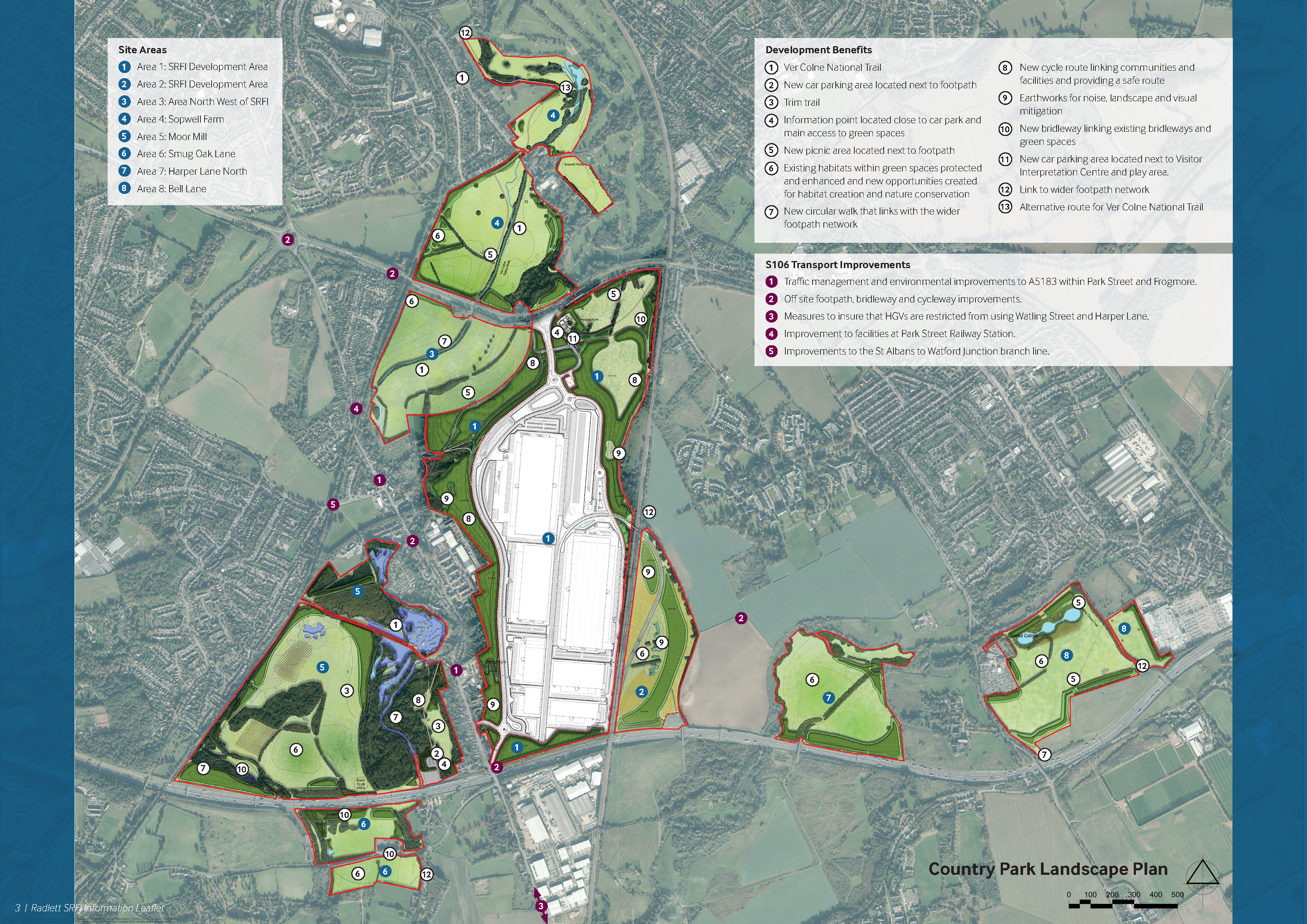
image
Home
335,000 sq m of state-of-the-art, sustainable logistics space, enveloped in 250 hectares of managed woodland and conservation grazing.
SEGRO Logistics Park Radlett
image
Master Plan
335,000 sq m of state-of-the-art, sustainable logistics space, enveloped in 250 hectares of managed woodland and conservation grazing.
Master plan
image
Contact us
Contact us to find out more about the plans for SEGRO Logistics Park Radlett and the surrounding area.
Contact us